


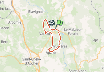
Malzieu /Tour d'apcher / Porte des fees

tyntyn
User

Length
21 km

Max alt
1070 m

Uphill gradient
479 m
Km-Effort
27 km

Min alt
858 m

Downhill gradient
478 m
Boucle
Yes
Creation date :
2025-07-15 06:26:56.966
Updated on :
2025-07-15 15:08:01.06
8h08
Difficulty : Medium

FREE GPS app for hiking
 SityTrail
IGN / Geographical institutes
SityTrail Plus
The world is yours!
About
Trail Walking of 21 km to be discovered at Occitania, Lozère, Le Malzieu-Ville. This trail is proposed by tyntyn.
Photos


Positioning
Country:
France
Region :
Occitania
Department/Province :
Lozère
Municipality :
Le Malzieu-Ville
Location:
Unknown
Start:(Dec)
Start:(UTM)
526356 ; 4966901 (31T) N.
Comments